A Columbia Valley Biking Getaway
By Janice Strong
Load up the bikes for a Columbia Valley biking getaway. The diversity and scenery of the bike trails around Invermere, Panorama, Windermere, and Radium invite mountain-bike riders of all skills for some great rides.
We packed the trucks with camping, hiking and biking gear and hitched up our RVs. Three friends and I put our mountain bikes on the bike racks and planned a weekend Columbia Valley biking and hiking vacation. Our goal was to explore as many of the intermediate cycling trails in the lower Columbia Valley as our time allowed.
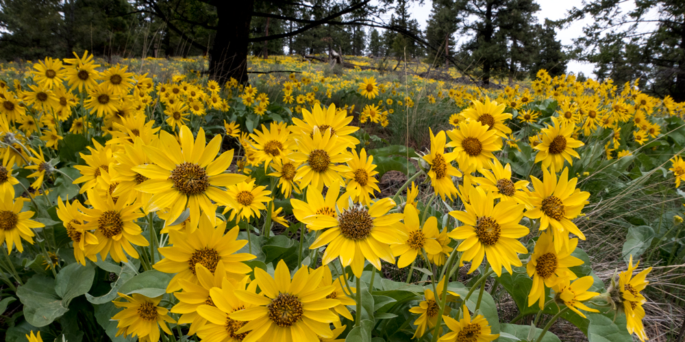
Biking around the low-elevation trails in June features landscapes of grasslands and meadows with a beautiful mix of colourful wildflowers.
Driving north up the Kootenay valley from Cranbrook, we passed Canal Flats, which is the divide between the Kootenay and Columbia valleys. The weather looked unsettled and we wondered about postponing the weekend jaunt. As we drove further north, the black clouds hugged the mountain peaks on both sides of the valley. Fleeting blue patches of sky spun between dark clouds, giving us hope that the weather would stay dry at least for our riding. The forecast predicted rain but by mid-morning it still had not yet rained. So we continued our plan and pulled into the campground.
Dry Gulch Provincial Park
http://www.env.gov.bc.ca/bcparks/explore/parkpgs/dry_gulch/
Our choice for accommodation was the quiet and clean Dry Gulch Provincial Park, just 4.5 km south of Radium. It has widely spaced RV and tent sites under a shady canopy of dense fir and pine forest and is a small, family-friendly RV park. As with many provincial parks in BC, they accept reservations for most of the 27 sites, and we had reserved two campsites.
We lingered in our RV drinking coffee while looking at trail info. The weather outside deteriorated with temperatures dropping and storms threatening to soak our bike-riding holiday. “Why are we doing this again?” — we questioned our logic.
“So… let’s just try out the trails anyway.” The four of us agreed, but if the trails were muddy we would respect accepted trail etiquette and not ride them. So we slung all four bikes onto the tailgate of one pickup and headed up to the trailhead.
Lake Lillian Trail Network – “Along the Johnson”
http://columbiavalleycyclingsociety.org
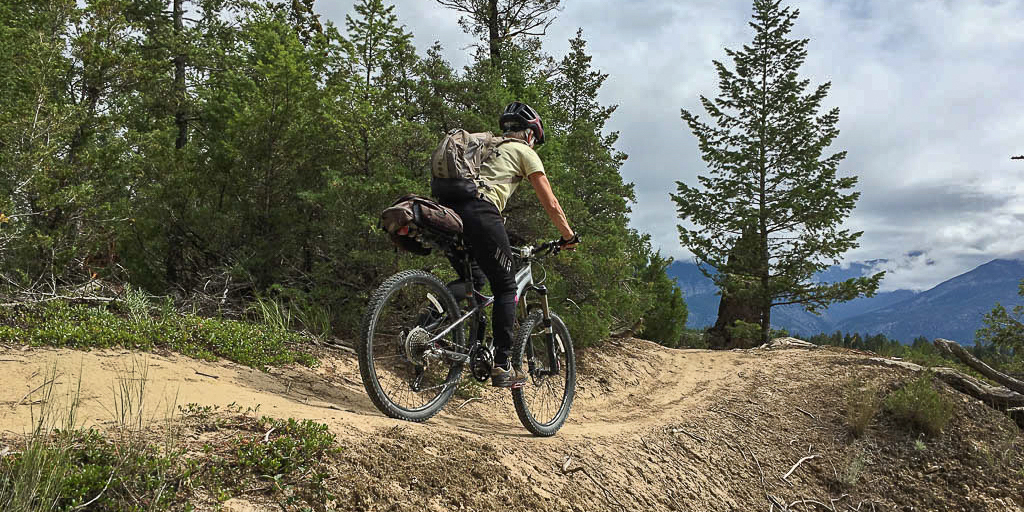
Our first stop on our Columbia Valley biking getaway was Lake Lillian. We soon found out why this trail network is so popular — it’s because of the fabulous canyon scenery and the quality trail layout and maintenance.
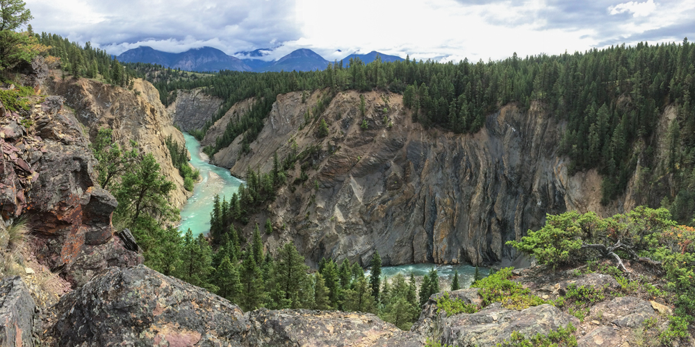
The dramatic Toby Creek canyon rim is the highlight of this bike trail network. The rim trail is called “The Johnson” and intermediate riders (blue) will feel comfortable riding it. The raging Toby Creek with its milky turquoise water surges about 70 metres below the rim. The canyon walls themselves are also intriguing, with vertical beige stone and segments of hoodoo-shaped amber slopes, and a couple of vermilion-coloured shale walls. (Riding along the edge is suitable for some, but I prefer to get off my bike and walk the scenic canyon rim sections of this trail network.)
Most of the bike trails wind through forest, grassland, and beside small creeks. The single-track trails are well graded, mostly on smooth dirt, with appropriate switchbacks, bridges and signage.
We rode the network of trails for several hours. The day turned out to have a mix of sun and cloud, and it didn’t rain, at least while we were on our bikes. But as soon as we got back to the truck the downpour began. Snug in our vehicle after the ride, we headed back into Invermere for coffee and sweets.
Trail Specs
- Rating: Most of this network accommodates intermediate riders (marked blue on the maps). But there are trails for every rider, from easy (green), to the steep, winding, and difficult trails (black diamond).
- Distance: 11 km for longest single loop, but it joins other circuits.
- Elevation Descent: About 60 m (200 ft.) from parking to canyon rim.
- Highest point: 945 m (3,100 ft.)
Driving Directions
- 0 km: Turn west from Highway 93/95 at the stop light for Invermere.
- 2.3 km: Turn right (north) at Panorama Ski Resort/Wilmer Road (signed) and stay on the main road as it bends left at the junction to Wilmer.
- 6 km: Turn right and park at Lillian Lake BC Recreation Sites and Trails. The bike trails are across the road (south) from a kiosk and map (N50 30.250 W116 05.754, at 928 m).
The next morning held more of the same weather, and we cupped our mugs of hot coffee for leisurely conversation in the warmer camper. Then we layered up in warm biking clothes and headed out again.
Old Coach Trail: Dry Gulch to Radium Hot Springs
Columbia Valley Greenways Trail Alliance manages Old Coach Trail https://www.greenways.ca/project/old-coach-trail/
I picked up a pamphlet about the trail at the Radium tourist information office. The brochure intrigued me with descriptions of a gentle ride, featuring wide views of the Columbia Valley Wetlands of the Columbia River.
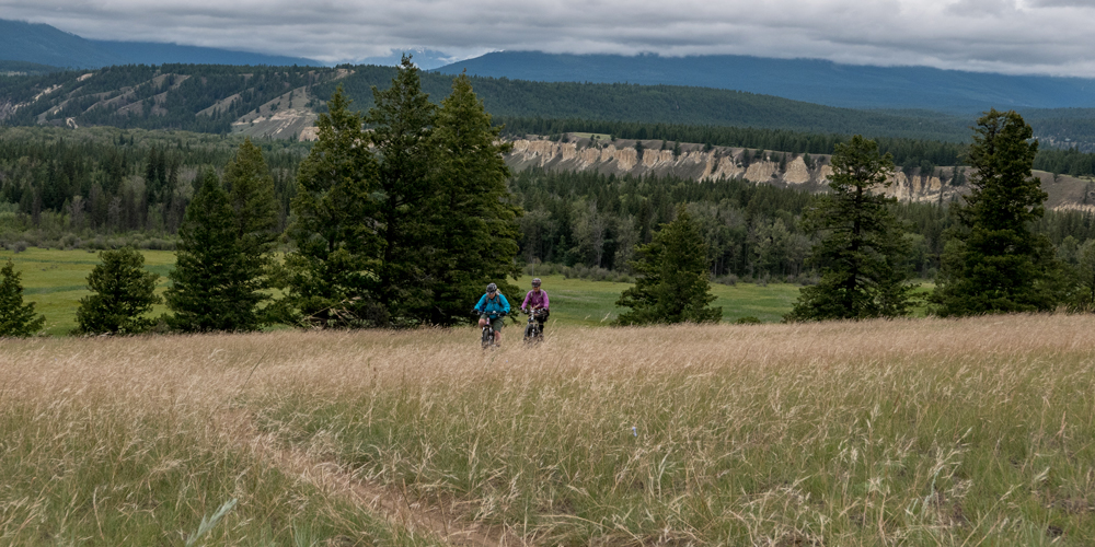
Old Coach Trail, as the name suggests, was at one time the main road along the steep banks of the Columbia River. We enjoyed the beautiful views of the Columbia Wetlands National Wildlife Area and the Purcell Mountains across the river. The sprawling, braided channels and ponds shimmered with reflected sunlight. The varied greens of marsh plants contrasted with the buff-coloured riverbanks.
We rode through several environments along the wide double-track old dirt road. In many places the trail climbs through forests of skinny Douglas fir trees, providing cooling shade to an otherwise hot ride.
On the way uphill toward Radium (the highest spot on the trail), we stayed on the moderate terrain of the (double-track) main trail.
For the way back down, we rode all of the short, intermediate (single-track) side loops. They added variety with fun ups and downs. The side loops also offered us the best views of the Columbia Valley Wetlands from high above the river. We rode the well-made tracks through grasslands.
These sandy terraces of grassland are becoming rare ecosystems and are remnants of ancient beaches left behind as the glaciers melted 11,000 years ago.
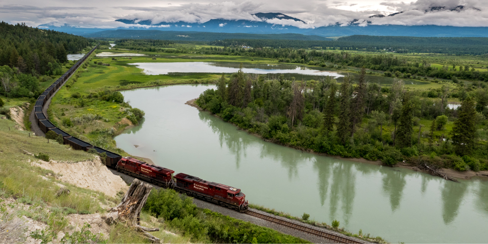
The railway tracks are far below the trail. From several view points trainspotters enjoy watching CPR trains loaded with coal from Elk Valley mines heading north to connect with the Trans-Canada line at Golden.
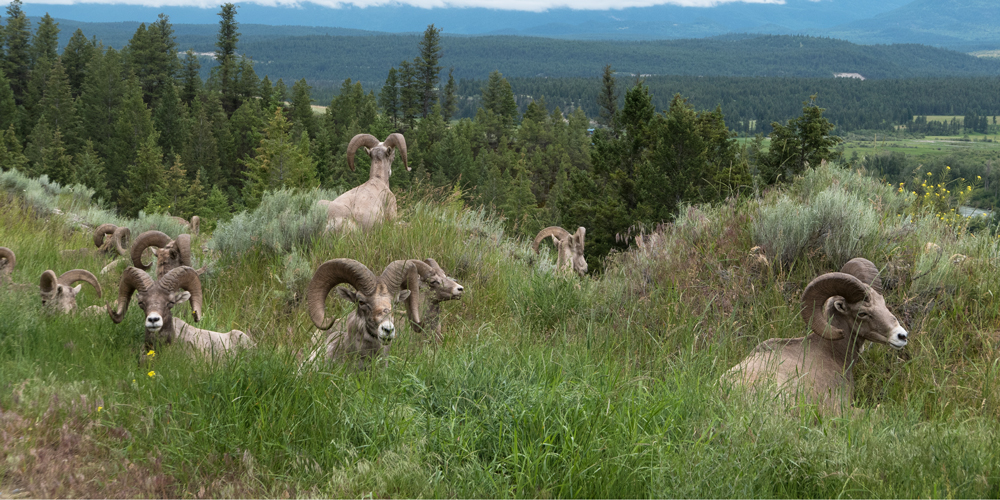
You may encounter Kootenay wildlife on Old Coach Trail, including Rocky Mountain bighorn sheep, deer, elk, grizzly bears, black bears or cougars.
Throughout the ride we watched intense storms swirl around the high mountain tops, and a chilly wind blew across the grasslands, but again, no rain fell while we rode our bikes.
After the rides we checked out the local brewpub and bought a few beers to drink back at camp.
Trail Specs
- Rating: Easily hike or bike some intermediate sections on the well-made side loops.
- Distance: 9 km one way
- Elevation gain: 172 m (560 ft.) total ascent
- Highest point: 900 m (2,950 ft.) just before Radium at the north end of the trail. Also, the north end has the steepest sections.
- Trail: Mostly wide old road with several ups and downs and some single-track loops. Fabulous views of the Columbia River and wetlands
Driving Directions
You can begin your Columbia Valley biking adventure at either the north trailhead, just south of Radium, or at the south trailhead near Dry Gulch. There are interpretive kiosks at both ends.
- From Radium — To access the north trailhead, look for a gravel road across from the visitor centre on Main Street, downtown Radium, then follow the signs.
For the south trailhead, keep driving until you see a small trail sign on your right, 6.6 km south of the four-way stop sign in Radium (1.5 km south of the Dry Gulch Provincial Park campground turnoff). Turn right onto the gravel road just after the sign, then follow the road to your left to a parking area.
- From Invermere — For the south trailhead at Dry Gulch, go north from the crossroads on Highway 93/95. Drive about 7.2 km then turn left opposite Eacrett Road into a large gravel parking area, signed Old Coach Trail. There is ample parking.
For the north trailhead, as you enter Radium watch for a gravel road on your left, opposite the visitor centre. Turn onto the gravel road and drive a short distance further to the gate.
About the Author
Janice Strong is the author of the popular guidebook Mountain Footsteps: Hikes in the East Kootenay of Southeastern British Columbia. It is published by Rocky Mountain Books.
Website: www.janicestrong.com